IDEM STRENGTHENS ITS EMPHASIS ON CONCEPTUAL SITE MODELS FOR ENVIRONMENTAL PROJECTS
If you haven’t already, you’ll soon be hearing a lot about Conceptual Site Models, or CSMs, for environmental projects in Indiana. CSMs have been used for decades in some quarters, particularly in federal programs, to guide environmental investigation and remediation. General discussions for developing and using CSMs appeared in U.S. EPA Superfund-related guidance documents in the late 1980s, and CSMs are an important part of EPA’s influential Soil Screening Guidance published in April 1996. ASTM published its first CSM standard guidance (ASTM1689) in 1995 (reapproved in 2008).
In spite of their longevity, CSMs historically have not been a staple of environmental site closures in Indiana. CSMs were only sparingly mentioned in the Indiana Department of Environmental Management’s (IDEM’s) Risk Integrated System of Closure (RISC) Technical Resource Guidance Document first issued in 2001. However, with IDEM’s newly refocused attention on risk-based closures, the May 2011 draft of the Remediation Closure Guide (RCG), which will replace the Tech Guide in early 2012, devotes five of its 13 sections specifically to CSM development under the topics of presampling and sampling activities, characterizing contaminant plume behavior, vapor migration, and background and off-site sources. These categories are subject to change when the final RCG is issued, but IDEM’s emphasis on CSMs is clear.
CSMs are basically formats (systems, frameworks, patterns) for (1) organizing and summarizing information already known or suspected about a contaminated site and (2) identifying information that must still be collected (data gaps) to more fully understand a site and to make sound decisions for the ongoing investigation and remediation. They focus not just on what contaminants are present, but how they move, what paths they follow, and how exposures occur – the whole picture.
CSMs have seven basic components (some authors list more components, some fewer):
- Site Description – the physical characteristics of the site, including the boundaries of the area to which the CSM applies,
- Contaminant Identification – the types, distributions, and concentrations of contaminants in site soil, groundwater, and air,
- Source Identification and Characterization – the locations and nature of primary source (initial release) areas and secondary sources (e.g., contaminated soil and groundwater) where releases occurred and from which contaminants have migrated or could migrate,
- Background Evaluation – comparison of concentrations of on-site contaminants to those found in similar, nearby areas not affected by historical site activities (generally applicable only to naturally occurring contaminants),
- Receptor Identification and Characterization – the types and locations of potential receptors (people, animals, and/or vegetation that could be exposed to site contaminants),
- Identification of Potential Migration Pathways – the processes and pathways through which contaminants have moved or could move in the environment from sources to receptors, and
- Current and Future Land Uses – scenarios for the site and surrounding areas that establish specific routes through which receptors come into direct contact with contaminants.
Environmental investigations usually progress through a series of steps comprised of data collection, evaluation, and assimilation into a growing body of information. A preliminary CSM is typically developed at the beginning of site characterization and is updated after each step as new information is gathered and analyzed.
Any clear, concise method for organizing and displaying site, contamination, and exposure information can be used to prepare a CSM – narrative text, maps and diagrams, tables, cross sections, graphs, etc. A common approach is to develop a narrative or bullet summary of known and missing information under each component category listed above and support the narrative with maps, tables, and other data presentations as necessary. In many cases, the CSM can replace typical report sections.
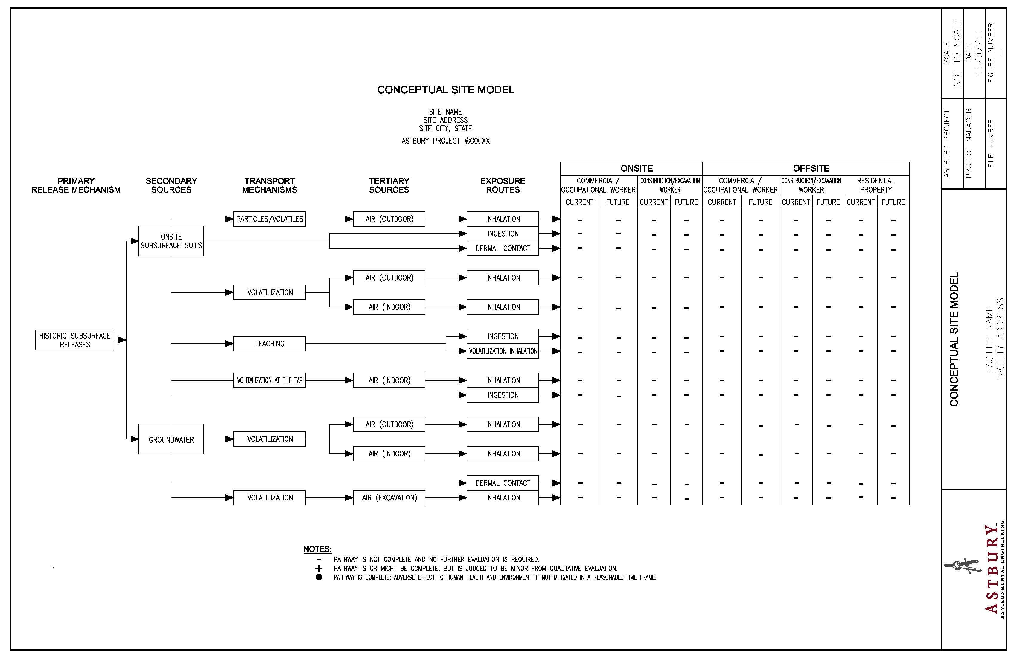
In addition to a narrative and tabular or graphical data presentations, CSMs also include a summary diagram that brings together the pathway- and exposure-related information of the CSM. CSM summary diagrams come in many forms and vary widely in their level of detail and complexity. You can see an example summary diagram by clicking on the link below. It is basically a flow chart that visually traces potential exposure pathways from sources, through environmental pathways, to potential on- and off-site receptors. Summary diagrams also help evaluate risk in terms of land use such as the residential and commercial/industrial scenarios, each of which has its own set of exposure assumptions. Like other parts of the CSM, the summary diagram is also updated to reflect our most current understanding of site conditions.
CSMs add a higher level of organizational efficiency and decision-making clarity to environmental investigations and remediation and will benefit all parties involved in the process – owners, consultants, and regulators. As the CSM evolves during an investigation, it provides a continuously improving basis for using multiple lines of evidence to either eliminate or retain certain pathways, receptors, and exposure scenarios in the site analysis and to determine which media or pathways require further investigation and perhaps eventual remediation. This progressive, systematic narrowing of focus allows our attention and resources to be concentrated on those pathways and exposure scenarios that pose the greatest potential health risk. Ideas for remediation approaches also begin to take shape during CSM development, and CSMs help tailor investigations to assist in selecting the most time- and cost-effective remediation methods for each site.

